Institutskolloquium PG: Towards Global Land-Cover Products from TanDEM-X: Algorithms and Challenges. – Mi. 05.07.2023
Towards Global Land-Cover Products from TanDEM-X: Algorithms and Challenges.
José Luis Bueso Bello (DLR/HR, Oberpfaffenhofen)
Moderation: Prof. Dr. Matthias Braun
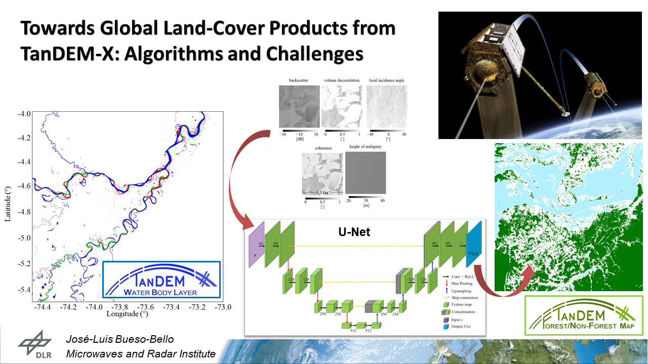
TanDEM-X is the first operational spaceborne bistatic SAR system comprising the two twin satellites TerraSAR-X and TanDEM-X. The system acts as a large single-pass radar interferometer, nominally acquiring interferometric SAR images in bistatic configuration with a resolution of about 3 m for the nominal StripMap mode. Its primary objective, the acquisition and generation of a global Digital Elevation Model (DEM) with 12 m horizontal resolution and 2 m relative height accuracy, was fulfilled in autumn 2016. The global interferometric SAR (InSAR) dataset acquired by the mission since 2010, represents a unique data source to derive geo-information products at large scale. In the bistatic TanDEM-X system, characterized by the absence of temporal decorrelation, the interferometric coherence adds valuable information to the common amplitude images, typically acquired by monostatic SAR systems, such as Sentinel-1.
In this talk, we will present the approaches implemented at the German Aerospace Center (DLR) to derive land-cover mapping products from TanDEM-X bistatic data, mainly focused on water detection and on forest/non-forest discrimination. In the case of the Water Body Layer (WBL), the bistatic interferometric coherence was used as the primary input feature for performing water detection. We classified water surfaces in single TanDEM-X images by considering the system’s geometric configuration and exploiting a watershed-based segmentation algorithm. Subsequently, single overlapping acquisitions were mosaicked together in a two-step weighting process to derive the global product, which comprises a binary averaged water/non-water layer as well as a permanent/temporary water indication layer. In the case of forest mapping, the volume decorrelation factor, which can be derived from the bistatic interferometric coherence, can be exploited as a reliable indicator of the presence of vegetation on ground. This quantifies the amount of decorrelation caused by volumetric scattering effects and it was already used as main input feature in the generation of the global TanDEM-X Forest/Non-Forest (FNF) map, by means of a Machine Learning (ML) clustering algorithm. In our work, we investigated the capabilities of Deep Learning (DL), and in particular of Convolutional Neural Networks (CNN), for mapping tropical forests at large scale using TanDEM-X InSAR data. For this purpose, we rely on a U-Net-like architecture, which takes in input a set of feature maps selected on the basis of previous preparatory works. An ad-hoc training strategy was designed, aimed at developing a robust model for global mapping purposes, which has to properly manage the large variety of different acquisition geometries characterizing the TanDEM-X global data set. By applying the proposed method on single TanDEM-X images, we achieved a significant performance improvement with respect to the baseline clustering approach, used for the generation of the TanDEM-X FNF map. The trained model was applied for mapping the entire Amazon rainforest, as well as the other tropical forests in Central Africa and South-East Asia, in order to test its robustness and generalization capabilities. The classification results of the CNN show an improved performance, especially in the case of dense forest areas, were the detected forest was represented in a contour closed region, and for acquisitions acquired with short baselines.
Actual on-going investigations point towards large-scale land-cover products, including more classes and based on different deep learning approaches. The importance of global land-cover and their changes are of high significance for many applications such as, agriculture, biodiversity and nature conservation, land use planning, natural capital accounting, climate change, etc. Global land-cover products such as the ESA World Cover, mainly based on Sentinel-2 optical data, classifies up to 11 land-cover classes. In our case, and with the main focus on regions typically hidden by clouds for considerable time periods, such as tropical areas, mountainous areas, or high-latitudes regions, we are investigating the capabilities of the TanDEM-X interferometric dataset to generate high-resolution products. By relying on self-supervised DL approaches and advanced interferometric processing techniques, large-scale products at 6 m are currently being generated. This will allow for the detection of forest disturbances, mainly caused by natural hazards or selective logging activities. Challenges and actual results will be presented at the seminar.
Wann: Mittwoch, 26.04.2023 von 12:30 bis 14:00 Uhr
Wo: Präsenz, Seminarraum Tennenlohe, Wetterkreuz 15, 91058 Erlangen.
Vortragsübersicht für das Institutskolloquium im Sommersemester 2023.
******
Fragen zum Kolloquium?
Organisation: Dr. Jan Winkler (KG) (jan.winkler@fau.de) & Dr. Sebastian Feick (PG) (sebastian.feick@fau.de)