International Humanitarian Mapathon 2023: 2753 buildings added @FAU
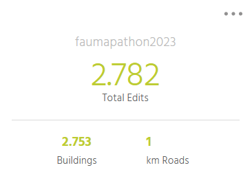
Update April 22: more than 2750 buildings were mapped and transferred to the OSM database by the mappers at FAU alone during the Humanitarian Mapathon. In total more than 10.000 buildings were added by all the mappers of the International Mapathon. This is great!!! As we learned in the keynote, this data can be used, for example, to improve risk assessments of earthquake prognosis – especially in regions where little geodata on buildings has been available so far.
In the final discussion on Friday, we discussed how the availability/quality of remote sensing data is also extremely unequal globally – datafication of the world is a new facet of socio-geographic inequalities…
We would like to thank our international partners for the invitation to the Mapathon and are already making plans for a Mapthon in 2024 – then, of course, again with the participation of FAU!
Georg Glasze, Dominik Kremer, Finn Dammann, Blake Walker & James Walker
****************************************************************************************************************************************
This year, FAU is participating in the international Humanitarian Mapathon for the first time. Together with students in California (USA) and Japan, we are supporting humanitarian mapping projects worldwide.
The Mapathon is open to all students (geography, human rights, digital humanities & social studies and all interested…).
The kick-off in Erlangen will be the Departmental Colloquium of Cultural Geography on Wednesday, April 19, starting at 12:30 p.m. Afterwards, there will be a basic on-site introduction to humanitarian mapping as well as the opportunity to begin guided mapping projects directly on-site in the FAU Geography computer labs.
- on site: Wetterkreuz 15, 91058 Erlangen-Tennenlohe (Seminarraum 1, ground floor: 49.543998N, 11.025177E) – getting there via public transport
- optionally, it is also possible to participate via the Zoom channel of the International Humanitarian Mapathon!
- all information for the Humanitarian Mapathon is available via Studon
https://www.studon.fau.de/crs5089774_join.html (Password “DigGeo”)
- Before the event:
– Please join the StudOn group
– there you will find the link to the International Mapthon and you can register for the Zoom room, which will be open during the entire Mapathon from Wednesday till Friday
– if you do not have an account with OSM and Humanitarian OSM yet: on the Mapathon website you will find the necessary information and links (registration takes a few minutes – please do it before Wednesday noon)
- for the Mapathon you can bring your own devices (notebook) – or you can use a computer in the Geography lab
Agenda on Wednesday:
- 12.30: Welcome and presentation of the International Mapathon
(Profs Walker & Glasze, FAU & Dr. James Walker FAU/UCLA)
- Keynote via Zoom: “Earthquakes and the role of humanitarian mapping”
(Dr. Daniel Schorlemmer, GFZ Potsdam & Humanitarian OpenStreetMap-Team Germany)
![]()
Abstract:
The substantial reduction of disaster risk and live losses, a major goal of the Sendai Framework by the United Nations Office for Disaster Risk Reduction (UNISDR), requires a clear understanding of the dynamics of the built environment and how it affects, in case of natural disasters, the life of communities, represented by local governments and individuals. Communities that participate in risk assessments increase their understanding of efficient risk mitigation measures. Earthquakes are threatening many regions in the world with constantly increasing risk due to rapid urbanization and industrialization. To improve resilience and preparedness, we need to estimate the risk, the possible damage, human and financial losses, on the basis of buildings. This requires not only the position, size and class of buildings, but also the reconstruction value and the number of people inside the building at any time. For this, exposure models are used that translate the physical earthquake hazard to building damage, human and financial losses. Exposure models usually describe the built environment of administrative regions as groups (aggregates) of different building classes and their frequency.
We present our open, dynamic, and global approach to describe, model, and classify every building on Earth with the greatest level of detail. Our model is based on the building data from OpenStreetMap and engineering information from open exposure models, combining these two source to a building-by- building description of the exposed assets. We retain the aggregated descriptions where the building coverage in OpenStreetMap is incomplete and describe every building separately where building data is available. Due to the near-realtime computations of our model, it directly profits from the growth of OpenStreetMap and with about 5 million buildings added each month (or approx. 2 per second), the areas of incomplete coverage are constantly shrinking, making way for our building-specific exposure model. Here, we introduce shortly the earthquake phenomenon, how it affects the built environment, why a high level of detail is necessary for useful assessments of the impact and the consequences of earthquakes, how OpenStreetMap and other open data helps us to achieve this goal and how communities can benefit for the model for their own risk assessments.
- Short practical introduction into humanitarian mapping in OSM (Dr. Dominik Kremer, DHSS FAU und Dr. Finn Dammann, Institute of Geography FAU)
- 13.45 Possibility to start mapping in the Computer Lab of the Institute of Geography (directly next to the seminar-room!)

- on-site mapping will be possible until at least 16.00 – questions can be answered on-site or via Zoom – afterwards mapping continues whereever you want…
- we propose to focus on two HOT-tasks:
- The FAU hashtag for the mapathon is:#faumapathon2023
The Humanitarian Mapathon will be running till Friday, 21st of April – the closing event will take place at 18.00 CEST in the Zoom room of the Mapathon.